
With the help of a major funding boost, the Ulster-Ireland section of the IAT continues to improve their trail.
Continue reading
Trail information, trip reports, trail status updates
With the help of a major funding boost, the Ulster-Ireland section of the IAT continues to improve their trail.
Continue reading
Back in August, 2019, Anouk Caron took a bus to Gaspé, Quebec to hike the SIA/IAT. During her hike she made the video below.
Continue reading
The IAT in Ulster-Ireland is about to receive a big upgrade thanks to a funding secured through a cross-border cooperation project between Northern Ireland and the Republic of Ireland as part of the Rural Development Programme.
Continue reading
SIA Spain has announced the completion of 48 kilometers of new trail for the Sendero Internacional de los Apalaches in the Ciudad Real Province.
Continue reading
, it took longer then we thought it would, but the first three sections of the IAT are now available in Guthook Guides. And by first three, we mean the original sections of the IAT: Maine, New Brunswick and Quebec.
Continue reading
Despite the ongoing ebb and flow of the Coronavirus, many IAT/SIA chapters are reporting fair to large numbers of hikers on their particular section of trail.
Continue reading
Trail updates from Newfoundland, Spain and Maine
Continue reading
The Sentier international des Appalaches – Québec has published its May, 2020 newsletter. In addition to COVID-19 related updates, it includes information for hikers on reservations and trail guides, and introduces Alexis Turcotte-Noël, the new director of SIA-QC.
Continue reading
As happens every spring, a dedicated group of Maine IAT volunteers spent a few days on the trail in the Katahdin Woods & Waters National Monument clearing winter blowdowns (aka wind-falls or windthrows), checking lean-tos and re-stocking toilet paper in the privies.
Continue reading
On August 24th in 2016, an 87,563-acre plot of land in the heart of Maine was designated the Katahdin Woods and Waters National Monument by former President Barack Obama. Although met with controversy on all sides, the area had yet been explored on a large scale. In September 2017, a team of four Maine-born photographers set out on a three-part journey through Katahdin Woods and Waters to investigate.
Continue reading
At their meeting in December, the Baxter State Park Authority closed access to Katahdin Lake along the route from the east while the park evaluates the potential impacts of the new Katahdin Woods and Waters National Monument.
Continue reading
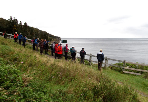
At the IAT Annual General Meeting in Strabane, Northern Ireland on September 22, IAT Ulster Ireland officials expressed interest in touring sections of IAT Scotland to learn about trail planning and development by their northern neighbour.
Continue readingOn August 24, U.S. President Barack Obama used his executive authority to create the Katahdin Woods & Waters National Monument on land donated to the federal government by entrepreneur and conservationist Roxanne Quimby. More than 87,500 acres of forestland in Maine’s fabled North Woods was designated in honor of the 100th Anniversary of the National Park Service, in a historic but unilateral decision following years of bitter debate.
![]()
The new national monument – which will be managed by the National Park Service – will include “the stunning East Branch of the Penobscot River and a portion of the Maine Woods that is rich in biodiversity and known for its outstanding opportunities to hike, canoe, hunt, fish, snowmobile, snowshoe and cross-country ski. In addition to protecting spectacular geology, significant biodiversity and recreational opportunities, the new monument will help support climate resiliency in the region. The protected area – together with the neighboring Baxter State Park to the west – will ensure that this large landscape remains intact, bolstering the forest’s resilience against the impacts of climate change.”
“Following years of support from many local and state elected officials, tribal leaders, businesses and members of the public across the state, this designation will build on the robust tradition of growing the park system through private philanthropy, and will reinforce the need to continue protecting our great outdoors as we enter the second century of the National Park Service. The land has been donated to the Federal Government by philanthropist Roxanne Quimby’s foundation, Elliotsville Plantation, Inc., facilitated by the National Park Foundation as part of its Centennial Campaign for America’s National Parks. In addition to the donation of the land, the approximately $100 million gift includes $20 million to supplement federal funds for initial park operational needs and infrastructure development at the new monument, and a pledge of another $20 million in future philanthropic support.”
With the stroke of a pen, Obama created the second national monument in Maine history after Acadia National Park’s precursor – on land east of Baxter State Park in an area facing severe economic uncertainty. The move is likely to delight conservation activists and infuriate local opponents fearful the designation is trading potential industrial-based opportunities in the Katahdin region for mostly seasonal tourism jobs. While organizations such as the Katahdin Area Chamber of Commerce hope it will lure more tourists and create jobs, opponents warned it could further destabilize a forest products industry struggling to rebound from the closure of the Millinocket and East Millinocket paper mills. Many others have mixed views, seeing significant jobs potential but not in the industry that was once the backbone of the region. Nevertheless, the designation is a substantial yet partial victory for Roxanne Quimby, the wealthy co-founder of the Burt’s Bees product line whose nonprofit, Elliotsville Plantation Inc., donated the land to the federal government this month. Quimby has pushed for years for a full-fledged national park in the North Woods but sought a lesser monument designation because it did not require congressional approval. On August 28, she was joined by Lucas St. Clair and his twin sister Hannah Quimby to host a grand celebration on the shores of Millinocket Lake at New England Outdoor Center’s Twin Pine Camps. The Natural Resources Council of Maine, The Wilderness Society, The Pew Charitable Trust, the National Parks Conservation Association, and the Conservation Lands Fund joined Roxanne, Lucas, and Hannah in thanking everyone who contributed to securing the designation of the Katahdin Woods & Waters National Monument by President Barack Obama. IAT Maine’s Don Hudson, Phine Ewing, Walter Anderson, Elaine and Eric Hendrickson, Lindsay and Michael Downing, Mark and Susan Adams, Bart DeWolf, former board member Eric Horschak, Aaron Meguier, Terry and Craig Hill, and numerous other IAT members and friends were on hand to bask in the great excitement and appreciation sparked by the Quimby family’s generous gift — the largest gift to the people of the United States since the days of John D. Rockefeller and Paul Mellon. The New England Outdoor Center’s Matt Polstein welcomed nearly 300 people to the formal gathering, looking out across Millinocket Lake to Katahdin, shortly after 5:00 pm. Sunday, August 28th. The highlight speeches were made by Secretary of the Interior, Sally Jewell and Liliane Willens. Secretary Jewell spoke about the significance of the gift to the nation, the importance of land such as this to the health and well-being of all Americans, and the special qualities of the land — the East Branch of the Penobscot, the hiking opportunities — especially the IAT, and the richness of the geologic heritage.
Liliane Willens, Roxanne’s aunt, regaled the crowd with stories about her family’s path from Russia, through Shanghai, to the United States beginning after the Russian Revolution and concluding at the end of World War II. Lily believes Roxanne developed qualities of perseverance, grit, and determination from her maternal grandmother, who had lead the family through much of that trek. When Lucas St. Clair addressed the crowd he too raised a great laugh of appreciation when he spoke about the power and dominance of women in his family, and how at a young age he learned not to second guess either his mother’s wisdom or her determination to get a job done. Lucas was clearly relieved that this particular job was done!
The hard-working staff of NEOC provided the wonderful setting for the gathering, along with delicious food and drink. Dave Mallett and his band took the party deep into the night with an endless serenade for the party-goers. The first 31 miles of the IAT is now on land considered by President Barack Obama to be a national treasure, and we agree!
When Bryson Guptill saw there was interest in the International Appalachian Trail on Prince Edward Island, he decided to try it out for himself. It took him and another six days to finish. “It was very cool”, he said.
Here’s Bryson’s story, as told by Charlottetown’s The Guardian newspaper. The International Appalachian Trail is part of network along the mountain range in the Atlantic provinces, Quebec, Maine, Greenland and several European countries. In P.E.I., the trail stretches 150 kilometres, including long stretches along the Confederation Trail. It’s an offshoot of the Appalachian Trail, which starts in Georgia, runs more than 3,500 kilometres to Mt. Katahdin in Maine and takes anyone dedicated enough to try it several months to finish.
Guptill said he made a map of what he thought was the International Appalachian Trail route in P.E.I., posted it to the Island Trails Facebook page and watched as interest spiked. Usually the page gets about 100 views in a week, but the map got more than 4,000 in the first day, Guptill said. “I thought holy crap there’s a whole lot more interest in the (International) Appalachian Trail than I had thought about.” Although he had the route mapped, Guptill said he wanted to make sure it was actually passable from start to finish. He said someone he knew had International Appalachian Trail signs someone sent her, but nobody ever placed them. So he took them and decided to walk the entire route.
Guptill walked the trail with an alternating group of people, including Sue Norton who kept him company throughout the entire trek starting in Borden-Carleton on July 6. They stayed in bed and breakfasts along the way, he said. “We thought that would be more fun than coming home.” Guptill said he had biked the trail before, but wanted to try it at a slower pace. “The thing is when you walk it you see so much more,” he said.During the International Appalachian Trail trip the weather cooperated and the temperatures stayed very cool, he said. Guptill also said he learned a lesson in the importance of putting some mileage on his feet before trying such a long hike. “Your feet just will take a pounding,” he said.
The International Appalachian Trail continues to draw hikers to northern Maine, offering a tour through varied landscapes and a connection to Canada and beyond.
This summer, the Maine chapter is aiming to reroute 52 miles of the trail that currently is set along roadways in southern Aroostook County. About 65 miles of trail are currently set along a road shoulder.
The roughly 13 miles along Grand Lake Road from Matagamon to Shin Pond is actually “good road walking,” with wide shoulders and few trucks, and that will remain a part of the route, Hudson said. For the other 52 miles, the chapter is working with landowners to reroute the trail from Shin Pond to Monticello, aiming to move the trail to old woods roads and all-terrain vehicle trails. A section they’ve secured will run along the south side of Mount Chase, and offer a link to a trail up the 2,440-foot mountain of the same name.
“The idea is in the long-run to get rid of the bulk of the road walking, and to use a combination of woods roads and paths,” including multi-use ATV trails, said Hudson, the former president of the Chewonki Foundation in Wiscasset.
For more on the story, go to the Bangor Daily News – Maine Outdoors website.
From September 19 to 25, IAT Ulster-Ireland will host the 2016 IAT Annual General Meeting in Strabane, Northern Ireland. The weeklong event begins at the Ulster American Folk Park in Omagh, where the IAT chapter was officially launched in August 2013.
It then moves west to Slieve League and the county of Donegal in the Republic of Ireland, where American Appalachian hiker Cotton Joe Norman began the first IAT Ulster-Ireland thru-hike in September 2013.
The trail starts at the 601 meter (1972 ft) Slieve League on the Atlantic coast then crosses the Blue Stack Mountains before entering Northern Ireland. It then picks up the Ulster Way and passes the Giant’s Causeway on the stunning northern coastline, before traversing the Glens of Antrim.
After Donegal, the AGM schedule moves to Derry/Londonderry for a pre-AGM tour, followed by the Annual General Meeting in Strabane. The tentative schedule of weeklong activities is:
A list of accommodation is being prepared, and it is hoped that delegates will stay in Castlederg / Derg Valley area of County Tyrone, close to the trail and border with County Donegal. Transport will be provided every day from and to Castlederg, including all trips up to and including the AGM in Strabane. On Friday morning, delegates will be transported to the North East Coast for the weekend’s itinerary.
For more complete visitor information, including transportation links and accommodations list, download the Delegate Information Guide, then go to the IAT Ulster-Ireland website and start planning your visit!
The International Appalachian Trail Newfoundland & Labrador (IATNL) has begun planning trail improvements for 2016, including on the Humber Valley Trail, Grand Codroy Way, and French Shore Trail near Conche, with volunteers Katie Broadhurst and Alex Fortin channeling girl power! They have recently begun developing a plan to increase the local volunteer base, in particular among young adults who appreciate outdoor adventure and physical fitness.
They are seeking adventure-loving low-maintenance volunteers to help on popular yet under-maintained scenic trails. There is lots to do, but they know how to get ‘er done and still have fun!
For 2016, volunteer “work” will include trail maintenance, new trail development, back country cabin renovations, and lots and lots of HIKING! The goal is to have one trail enhancement project per month, whether one day local or multi day back country.
Plans call for a kick off in May with a gathering of volunteers to review the summer plan, cover basic trail maintenance techniques, and meet all of the fellow volunteers! They will then put it all into action with a little maintenance on the Old Man in the Mountain section of the Humber Valley Trail.
For more on the story, go to the IATNL website.
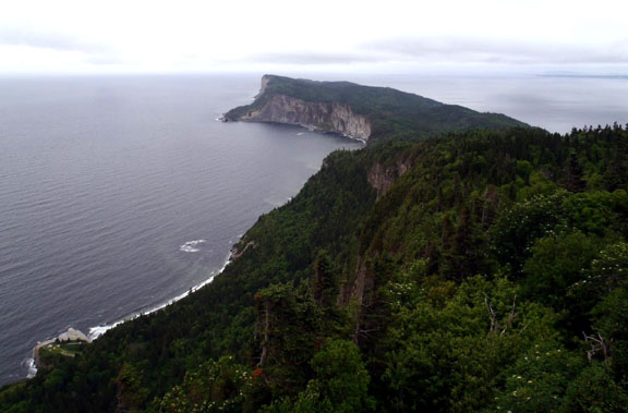
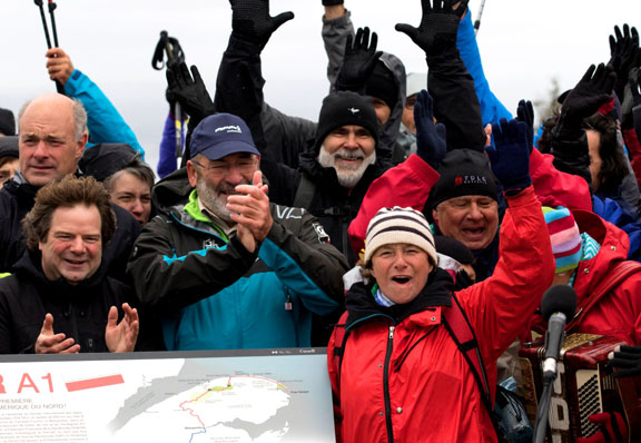
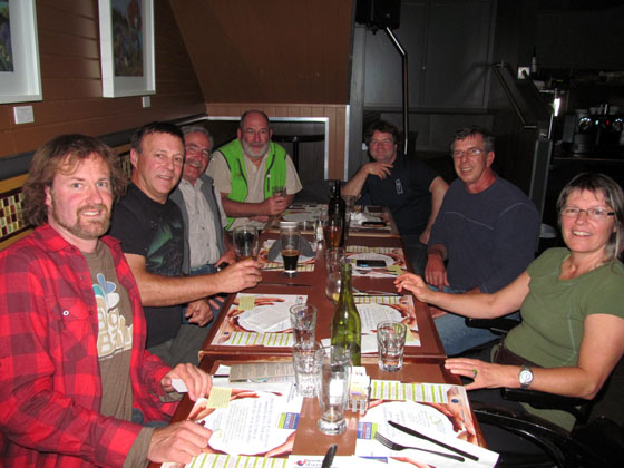
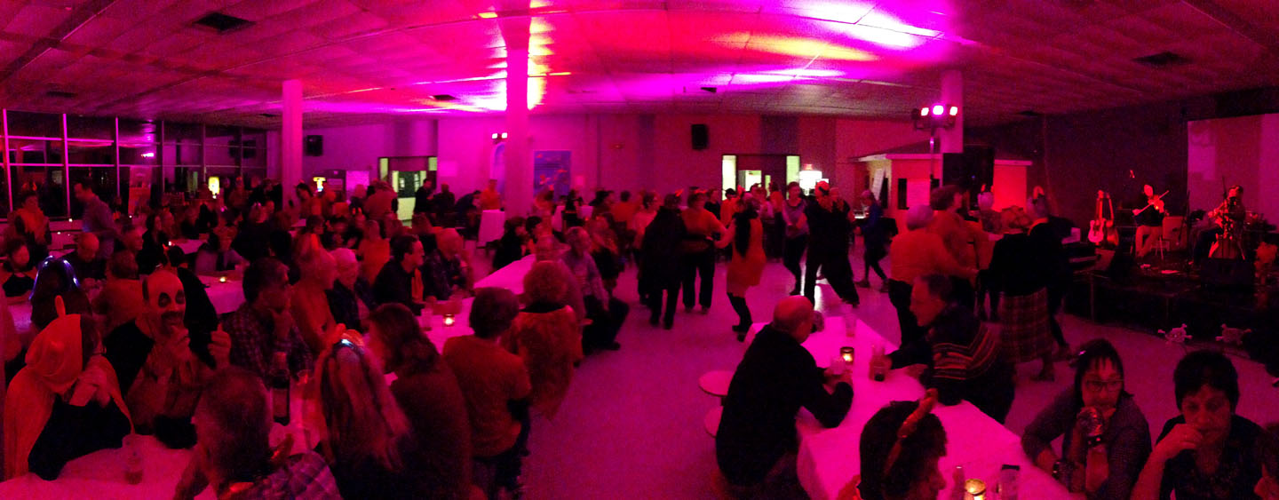
On October 2, the International Appalachian Trail Québec and France’s Fédération Française de la Randonnée Pédestre (FFRP) officially designated IAT Québec (IAT-QC) as North America’s first Grande Randonnée (“Great Hike”) – the GRA1 (America 1) – at Forillon National Park.
![]()
The international event took place at Cap Gaspé and marked the closing of the second Traversée de la Gaspésie (TDLG) on Foot (TDLG) on Foot, which ran from September 26 to October 3.
The GR designation is part of an international strategy aimed at strengthening ties between IAT Québec and the Fédération Française de la Randonnée Pédestre (French Hiking Federation) and promoting hiking in Western Europe and North America.
The FFRP first traveled to Gaspésie with information on the GR program in October 2013. In 2014, IAT Québec was granted GR designation, with permission to use the famous white and red trail markers.
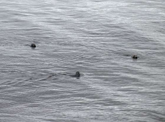
The October 2 Launch was preceded by an IAT/FFRP dinner and refreshments at Brise Bise pub in the town of Gaspé and a morning trek along the coast of Forillon National Park where hikers were treated to about a dozen gray seals who swam in for the celebrations!
These began with music and song along the trail and in the lighthouse shed where approximately 100 hikers gathered for the main event!
![]()
Next up was opening introductions and official statements by Parks Canada, IAT, TDLG and RRPF officials followed by the unveiling of a new GRA1 sign to more music and much applause.
The bilingual sign describes IAT Québec and the GR® designation and outlines the route on a map of the Gaspé Peninsula.
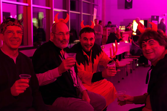
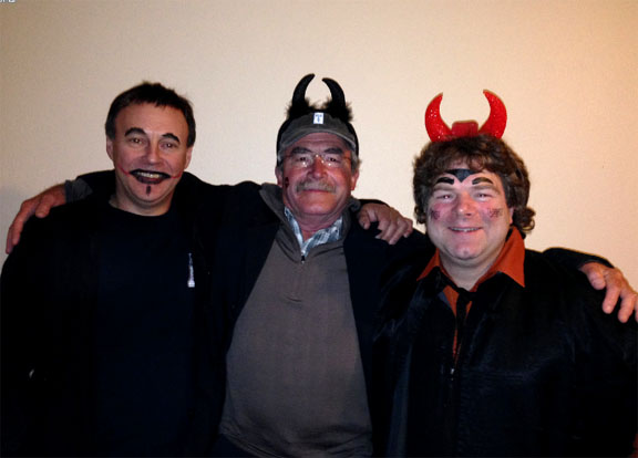
The festivities continued throughout the day, and ended at night with a satanic themed costume party in the town of Gaspé. For more information on IAT Québec and the new GRA1, go to the SIA-IAT website. If you see any devils along the route, touch a trail marker and tell 10 friends they must walk the IAT!!!
On the beautiful morning of August 17, IAT/IATNL Chairperson Paul Wylezol and IATNL Finance Director Kevin Noseworthy set off in a dory from Cox’s Cove, Bay of Islands with Darren Park of Four Seasons Tours in search of Middle Arm geosites for the IATNL planned Cabox Global Geopark.
The Geopark will feature 3 basic zones of the Humber Arm Allochthon: the Ancient Continental Shelf of North America, the Transported Continental Margin of North America, and the Bay of Islands Complex Ophiolite Massifs.
The tour’s first stop was Middle Arm Point between Humber Arm and Middle Arm. Its exposed and weather-beaten headland is a good example of the Zone 2 Cook’s Brook Formation.
![]()
There you can see layers of sedimentary limestone and sandstone folded in unique patterns when tectonic collisions closed the Iapetus Ocean and formed the Appalachian Mountains more than 250 million years ago.
![]()
![]()
From Middle Arm Point, the trio turned back and headed east into Goose Arm and the rising sun. For more on the story, go to the IATNL website.
In July 2015, the International Appalachian Trail crossed the Mediterranean Sea from Spain into Morocco. The addition of the African country marks the third and final continent of IAT expansion beyond borders to all “Appalachian” regions once connected on the super-continent Pangea more than 250 million years ago, when the Appalachians, Caledonians, and Anti Atlas Mountains were formed.
![]()
The first phase of IAT Morocco will extend approximately 600 kms from Midelt to Taroudant and be divided into 3 sections – Midelt to Megdaz, Megdaz to Imlil (High Atlas Central), and Imlil to Tagmout (near Taroudant) – taking a combined 40+ days to complete on foot.
Along the way, hikers will experience geography, culture and religious traditions unlike anything previously experienced along the IAT, from deserts to Berbers to the Muslim call to prayer.
Highlights include Jebel Ayachi (the highest peak in the middle Atlas), 700m high Tatrout gorge, the famous Plateau Lakes and fortified cliffside village of Irherm n’ Ouchtim, the ridge of Mgoun (the second highest peak in North Africa) and Megdez, arguably the most beautiful village in the Atlas Mountains.
Next up are Anghomer Pass (Tizi n’Timlilt, 3100m) and the tremendous views of Ouazarzate and Jebel Sahro range, Ardrar Mahboub with its superb views south towards the Sahara, Yagour Plateau (well-known for rock carvings), and Mount Toubkal, at 4167m, the highest peak in the High Atlas and North Africa.
Others include the Sultan’s Kasbah Gandafa Palace (17th century), Tinmal Mosque (12th century), Jebel Imaradene summit, and the plateau of a thousand peaks.
The IAT Morocco blaze (i.e., trail marker) contains the familiar IAT/SIA layout, with the addition of the country’s flag on top and IAT QR code at bottom.
![]() Blazes are currently being installed along the route, with the assistance of IAT partner Morocco Trek and local volunteers. Hikers looking for assistance in finding the route and planning their IAT Morocco adventure can contact Morocco Trek at http://www.moroccotrek.co.uk/.
Blazes are currently being installed along the route, with the assistance of IAT partner Morocco Trek and local volunteers. Hikers looking for assistance in finding the route and planning their IAT Morocco adventure can contact Morocco Trek at http://www.moroccotrek.co.uk/.
On a sunny Saturday, May 9, 2015, Sally Magnusson, broadcaster, top news presenter for BBC Scotland, writer and journalist, officially opened the 161-mile (266km) Firth o Clyde Rotary Trail in Milngavie – next to the start of the West Highland Way – in front of members of the public, the Rotary Clubs of Stranraer, Ayr, Gourock, Allander, and their guests – including IAT Europe vice-president Hugh Barron representing IAT Scotland.
Rotary could not have chosen a better person for the job, as Sally’s late father was the celebrated Icelander Magnus Magnusson, presenter of the BBC “Mastermind” Quiz Show, one-time President of Scottish Natural Heritage, and also the “Paths For All” Charity who encourage local footpath development and healthy exercise.
Plaque at Milngavie Introduced by her host, Iain White (Allander and the new Clyde Coastal Path), Sally unveiled two commemorative plaques – one of which had been carried in relay by teams of Rotarians to Milngavie all the way from the Mull of Galloway (to where it will return). A keen walker herself, she duly declared – ‘Scotland is rich in beautiful places to walk, but for me there is nothing better than a coastal path, and I look forward to walking this one’.
Tom Stevenson (Stranraer and the Mull of Galloway Trail) then presented her with a cheque for £1000 for her charity in memory of her late mother Maimie, also a famous journalist – ‘Playlist for Life’ (providing favourite music for dementia sufferers’ on iPod).
In thanking Sally, Jimmy Begg (Ayr and the Ayrshire Coastal Path) said this occasion was the realisation of an eleven-year aspiration; and paid tribute to the huge amount of work undertaken – firstly by members of Ayr Rotary Club in creating the Ayrshire Coastal Path in 2008, and then to the members of Stranraer Rotary Club who rose to the challenge to connect up the Mull of Galloway in 2012 – and to Gourock and Allander Rotary Clubs, who did likewise with the final link, the Clyde Coastal Path in 2015.
He also thanked Scottish Natural Heritage and Visit Scotland for the accolade of Scotland’s Great Trail awarded to both the ACP and the MGT, and made special mention of the excitement and pleasure they’d felt away back in Oct 2010, when the International Appalachian Trail invited the ACP (and subsequently the MGT and CCP trails) to become part of IAT Scotland, forming a vital link with Ireland and the West Highland Way.
Now complete, the Firth o Clyde Rotary Trail (FoCRT) will prove a major asset to the Scottish walking tourism industry, linking as it does with a number of existing long-distance routes in Scotland. The tough/gentle nature of the trail should encourage everyone – from families on a day out to serious walkers – to take to the outdoors, and enjoy the stunning scenery and superb natural environment.
FoCRT comprises three autonomous long distance trails, the Ayrshire Coastal Path (2008), the Mull of Galloway Trail (2012) and the Clyde Coastal Path (2015), created by the Rotary Clubs of Ayr, Stranraer, and Allander and Gourock, respectively.
The Mull of Galloway Trail (36 miles/60km) starts at the Mull Lighthouse, perched on steep cliffs at the southernmost point in Scotland, with fine prospects of the Isle of Man and Ireland’s Mountains of Mourne, before travelling up the sheltered eastern shore of the Rhinns, with big sky views over Luce Bay to the Machars and the distant Galloway Hills. Passing through rich farmland, it crosses the Southern Upland Way near Stranraer, then follows the Coastal Path along Loch Ryan, with its fascinating smuggling, WW2, and rich ancient history. From Cairnryan it climbs on to high moorland with magnificent views of loch, sea, and hills, before the descent to Glenapp.
From Glenapp to Skelmorlie, the Ayrshire Coastal Path runs for 100 miles (161km) along one of Britain’s finest panoramic coastlines, with iconic Ailsa Craig and Arran always in the frame. Walkers, will tramp the native heath of Scotland’s three greatest heroes – Robert Burns, King Robert the Bruce and Sir William Wallace – over a land steeped in history, and teeming with wildlife. Firstly, along wild cliff-top tracks, old turnpike roads and rough and sandy beaches; past ruined castles and small fishing villages – by the Open Championship golf course at Turnberry and through the grounds of Culzean Castle. From Ayr northwards, the going is much gentler along sandy beaches past Prestwick – the birthplace of Open championship golf – and its successor, Royal Troon, From Ardrossan to Largs, sailing yachts now glide calm seas once scoured by fearsome Viking longships.
The Clyde Coastal Path (27 miles/45km) provides low and high-level routes to Greenock from the north end of the ACP at Wemyss Bay, then over the Erskine Bridge to the start of the West Highland Way at Milngavie. The Low Road has easy walking from Wemyss Bay along Ardgowan shore and the quayside promenades of Gourock, Greenock and Port Glasgow. Serious walkers on the High Road along the Kelly and Greenock Cuts, have superb views of the Clyde Estuary and distant Highland hills. Over the Erskine Bridge, the route follows part of the Roman Antonine Wall, then rises over Douglas Muir – with great panoramic views of Glasgow and the Clyde – before descending to Milngavie.
The International Appalachian Trail Scotland Route – and links south and west:
Having now completed the Firth o Clyde Rotary Trail (161 miles) from Mull of Galloway in the south-west, the intrepid walker will now take the iconic West Highland Way (96 miles) from Milngavie to Fort William, then tramp along part of the Great Glen Way, before joining the unmarked Cape Wrath Trail, which traverses 200 miles of magnificent wilderness to finally reach another spectacular lighthouse over towering cliffs at Scotland’s most north-westerly point.
As part of the International Appalachian Trail Scotland, looking to the west and south, FOCRT forms a strategic link with IAT Ireland – and potentially England – and is set to play an increasingly important part in the development of South West Scotland’s walking tourism.
NB. FoCRT is the umbrella title for the first section of the International Appalachian Trail Scotland, and its website (www.focrt.org) should simply be used to fast-link to the websites of its three constituent paths, from which walkers can gather all the info needed to plan their route.
Jimmy Begg, Rotary Club of Ayr
Route Manager, Ayrshire Coastal Path 8 May 2015
In 1498, just one year after Italian explorer Giovanni Caboto rediscovered North America and six years after fellow Italian Christopher Columbus “discovered” the New World, Portuguese explorers João Fernandes Lavrador and Pêro de Barcelos were the first modern explorers of much of northeastern North America, including the Labrador Peninsula. They were followed (1500-02) by Portuguese explorers Gaspar and Miguel Corte Real. This is the story of Portuguese exploration of North America, the fourth in the IAT Natural and Cultural Heritage Series.
In 1295, when Italian merchant Marco Polo returned to his native Venice after 24 years travelling across Asia to China with his father Niccolò and uncle Maffeo, few Europeans had any knowledge of lands beyond the Near East, where four years earlier, 200 years of Christian military campaigns to the Holy Land known as the Crusades had ended.
However the Polos returned at a time when Venice was at war with Genoa, another wealthy Italian city-state with an extensive Mediterranean trading network. After outfitting a galley for war, he was soon captured and imprisoned for approximately 3 years, during which time he dictated a detailed account of his travels to fellow prisoner Rustichello da Pisa, who after adding his and other tales, published a book with the English title The Travels of Marco Polo.
Though written before the invention of Gutenberg’s printing press (c. 1439), the book was widely copied in many languages, inspiring merchants, seamen and nobility with tales of riches in the far east. Already experienced traders in the eastern Mediterranean, Italian city-states were well positioned to capitalize on increased trade with Arab and Turkish middlemen.
However in the early 15th century, another bold and visionary European had another idea. He would pursue trade directly with the far east, avoiding non-Christian middlemen. Portugal’s Infante Dom Henrique de Avis, Duke of Viseu, better known in the 20th century as Henry the Navigator (1394-1460), would devise a plan to reach Asia by sailing around Africa, from the Atlantic to Indian Ocean.
In 1415 at the age of 21, Henry convinced his father, King John I, to conquer the port of Ceuta on the North African coast. This Moorish stronghold in the Strait of Gibraltar had long been used as a base for Barbary pirates who raided the Portuguese coast, capturing locals and selling them in the African slave market. Soon after, he was exploring the West African coast, hunting pirates and seeking the source of the area’s lucrative gold trade and the legendary Christian Kingdom of Prester John.
Because Mediterranean ships of the era were too slow and heavy for these dangerous forays into the Atlantic Ocean, a new and much lighter ship was developed that was faster and more maneuverable. Rigged with 2 or 3 lateen sails, these shallow-keeled Portuguese caravels of 50 to 150 tons were able to tack against the wind and sail upriver into shallow coastal waters.
Soon Henry’s explorers were discovering new lands in the eastern Atlantic, including the Madeira Islands (1420) and Azores (1430), which were quickly colonized. They also discovered the volta do mar (Portuguese for “turn of the sea“), the navigational technique whereby mariners returning to Portugal from the west coast of Africa had to follow the clockwise currents and trade winds and sail northwest to reach northeast. This was a major innovation in Atlantic navigation that would play a major role in future exploration. By the time of Henry’s death in 1460, Portuguese caravels had discovered the Cape Verde Archipelago and circumvented the Muslin land-based trade routes across the western Sahara Desert, thus enabling direct trade for gold and slaves.
During the generation that followed, Portuguese explorers continued south along the west coast of Africa until 1488 when Bartolomeu Dias sailed around the southernmost tip of the continent, becoming the first European to reach the Indian Ocean from the Atlantic. Four years later in 1492, Christopher Columbus followed the volta do mar on his first voyage west across the Atlantic Ocean in search of the East Indies.
On October 12 he landed on a Bahamian Island which he claimed for supporting monarchs Ferdinand II of Aragon and Isabella I of Castile, after being rejected by King John II of Portugal on the basis that his estimated travel distance of 2400 miles was far too low and Diaz had already rounded the “Cape of Good Hope” for an eastern maritime route to Asia.
This new discovery precipitated a dispute between Spain and Portugal, which had been granted all lands south of the Canary Islands in the Alcaçovas Treaty of 1479, which ended the War of the Castilian Succession (1475-1479). The dispute was resolved by the Treaty of Tordesillas in 1494, which divided all new lands in the Atlantic Ocean between the Portuguese and Spanish empires along a meridian 370 leagues west of the Cape Verde Islands, approximately halfway between those islands and the islands discovered by Columbus in 1492. Lands to the west of the meridian would belong to Spain, while lands to the east would belong to Portugal.
In just three years, Venetian Giovanni Caboto became the first European to reach Newfoundland in North America since the Norse Greenlanders, approximately 500 years earlier. Sailing with a royal patent from England to find a northwest route to the East Indies, his discovery would complicate future Portuguese and Spanish claims to the New World.
That same year, Vasco da Gama departed Portugal for India, following Diaz’s route south into the Indian Ocean, where in 1498 he became the first European to reach India by sea. Two years later, countryman Pedro Álvares Cabral followed the counter clockwise ocean currents and trade winds of the South Atlantic on his voyage to India, and in the process discovered the northeast coast of South America, claiming the future “Brazil” for Portugal.
![]()
While Cabral was exploring the southwest Atlantic, Portuguese explorer Gaspar Corte-Real and his brother Miguel were exploring the northwest and reached what is believed to be Newfoundland. Though Miguel returned to Portugal with two of the expedition’s three ships, Gaspar continued southwards and was never heard from again. Miguel met the same fate the following year, when he set off in search of his younger brother. As a result of these voyages the names Terra Cortereal and Terra del Rey de Portuguall began to appear on European maps of the day.
The Corte Reals were following in the wake of fellow Azores countryman João Fernandes Lavrador, who in 1498 was granted a patent by Portuguese King Manuel I to search for new lands on the Portuguese side of the Tordesillas Meridian. He reached Greenland and Labrador, named Island of Labrador and Land of Labrador, respectively, and was granted title to many of the lands he discovered. In 1501, he too was lost at sea in the North Atlantic.
The Portuguese Pedro Reinel Map of 1504, the world’s first to include lines of latitude, clearly shows the Canadian regions of Labrador, Newfoundland and Cape Breton, as well as the Strait of Belle Isle and Cabot Strait.
![]()
500 years earlier, the coast of Labrador and Strait of Belle Isle were familiar to Norse explorers from Greenland, beginning with Leif Erikson who established the settlement of Vinland at the tip of Newfoundland’s Great Northern Peninsula.
In 1534 and 1535, Jacques Cartier entered the Gulf of St. Lawrence via the Strait of Belle Isle during his first two voyages of discovery. In 1536 after overwintering in “Canada”, he returned to France via the Cabot Strait, thus becoming the first European on record to determine Newfoundland to be one or more islands.
![]()
Though the first French explorer of “Canada”, Cartier was not the first explorer flying the French flag in North America. in 1524, Florentine Giovanni da Verrazzano explored the east coast from North Carolina to Newfoundland in the service of King Francis I.
For the next half century, the Strait of Belle Isle continued to establish itself as Canada’s Heritage Gateway, when whaling fleets from the Basque region of France and Spain (whose King Phillip II was also crowned Philip I of Portugal in 1581) hunted right and bowhead whales as they migrated through the strait between the Gulf of St. Lawrence and Labrador Sea.
In spite of the Portuguese claim to North America under the Treaty of Tordesillas and the voyages of João Fernandes Lavrador and Gaspar Corte-Real, Giovanni Caboto’s discovery of Newfoundland on behalf of King Henry VII of England one year before Lavrador’s voyage in 1498 established “British title to the territory composing [Canada and] the United States. That title was founded on the right of discovery, a right which was held among the European nations a just and sufficient foundation, on which to rest their respective claims to the American continent. Whatever controversies existed among them (and they were numerous), respecting the extent of their own acquisitions abroad, they appealed to this as the ultimate fact, by which their various and conflicting claims were to be adjusted.” (Commentaries on the Constitution of the United States, by Joseph Story, LL. D, U.S. Supreme Court Justice, and Dane Professor of Law, Harvard University, 1833).
The English claim to North America was disputed by its historic rival France, based on the voyages of Jacques Cartier who discovered the St. Lawrence River and the interior of “Canada”. After the English victory in the Seven Years War (French and Indian War in North America, 1754-1763), England finally gained possession of the continent and quickly employed James Cook to survey and chart the Strait of Belle Isle and French Shore of Newfoundland, which together with the islands of St. Pierre and Miquelon, were the only remaining territories under limited French control.
The victory was short lived. Twenty years later, England lost the southern half to the American States during the Revolutionary War for independence.
As for Portugal, they continue to fish in Newfoundland waters, an enduring tradition lasting over 500 years. In Labrador, one of the biggest employers today is the mining company Vale, a Portuguese language multinational based in the Tordesillas Meridiancountry of Brazil.
And in Portugal, the country proudly remembers their classic age of exploration, a time when their country was without equal on the high seas.
On March 28, 2015, IAT Portugal will officially launch the GR38 – Grande Roto Do Murada l-Pangeia as the Trilho Internacional dos Apalaches Portugal.
![]() Dr. Fernando Marques Jorge, Mayor of Câmara Municipal de Oleiros will preside over the event to be held at Naturtejo Geopark in the foothills of eastern Portugal.
Dr. Fernando Marques Jorge, Mayor of Câmara Municipal de Oleiros will preside over the event to be held at Naturtejo Geopark in the foothills of eastern Portugal.
![]()
Also in attendance will be IAT Portugal Coordinator Carlos Neto de Carvalho, Geologist and Scientific Coordinator at Geopark Naturtejo, IAT Chairperson Paul Wylezol, Canadian Consul to Portugal David Marion and IAT Spain Coordinator Ruth Hernandez.
The event will feature walking adventures and folk music and continue on March 29 with outdoor theater and a gastronomical festival.
The municipality of Oleiros voted in favor of including the Grand Route Muradal-Pangea as the centerpiece of an IAT Portugal in July 2013. Since then, trails have been developed and signage erected.
![]()
Stay tuned for more news on the IAT Portugal Launch and the next installment of the IAT Natural and Cultural Heritage Series, featuring the historic maritime connection between Portugal and North America.
![]()
Now the time has come to walk and celebrate the Trilho Internacional dos Apalaches Portugal!
On May 30, 2015, Scotland’s Stranraer Rotary will hold its third annual walk/run over the stunning marathon length of the Mull of Galloway Trail, from the Mull of Galloway to Stranraer. The 26 mile route across mostly rough path will begin at 10am.
![]() For the less adventurous, there will be a 10 mile walk/run from Sandhead to Stranraer over rough path and tarred roads with light traffic. It will start at 11:30am at Tigh na Mara Hotel, Sandhead.
For the less adventurous, there will be a 10 mile walk/run from Sandhead to Stranraer over rough path and tarred roads with light traffic. It will start at 11:30am at Tigh na Mara Hotel, Sandhead.
![]() There will be an entrance fee of £25 per person for the longer course and £15 for the short course. This includes transportation from the start at Stranraer marina to the Mull of Galloway or Sandhead, and a barbecue and complimentary drinks at the finish.
There will be an entrance fee of £25 per person for the longer course and £15 for the short course. This includes transportation from the start at Stranraer marina to the Mull of Galloway or Sandhead, and a barbecue and complimentary drinks at the finish.
![]() Unlike previous years, there will not be a yachting component to the race, but there will be places on Sunday when yachts will host runners for a (weather permitting) trip round Ailsa Craig. These places will be limited and so there may be a ballot.
Unlike previous years, there will not be a yachting component to the race, but there will be places on Sunday when yachts will host runners for a (weather permitting) trip round Ailsa Craig. These places will be limited and so there may be a ballot.
![]() Various types of accommodation are available and organisers can advise how to maximize the enjoyment of your stay.
Various types of accommodation are available and organisers can advise how to maximize the enjoyment of your stay.

The creators of the Mull of Galloway Trail in southwest Scotland are shocked by the damage caused by a recent January storm. Members of the Stranraer Rotary Club walked the trail – which joined the IAT in May 2013 – to view the impact of the wind and high tides.
Continue reading